Additional Maps
This page contains a few packages that contain map data for the Qt version of Marble. You can install this data manually. Users of the KDE version can get these maps with Download maps... in the File menu You have to extract these files into Marble's maps directory. On Windows this is data/maps in your Marble installation. On Linux you will find it in $XDG_DATA_HOME/marble/maps while $XDG_DATA_HOME is usually ~/.local/share.
Here's an example for Linux and the Historical Map 1570: Download the map theme using the download link in the table below, saving the file as ortelius1570-marblemap.zip. Open a shell and run
unzip -d ~/.local/share/marble/maps ortelius1570-marblemap.zip
Now you just need to run Marble and select the newly installed map theme.
| Preview | Description | Package |
|---|---|---|
|
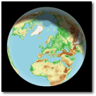
OpenTopoMap A free topographic map which has been created from OpenStreetMap and SRTM data. The map style is inspired by official maps and focuses on legibility through high contrast and balanced signatures. Credits: Map data: © OpenStreetMap Contributors, SRTM | Map style: © OpenTopoMap. Author: OpenTopoMap License: Creative Commons-by-SA 2.0 |
Download version 0.2 |
|
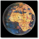
Behaim Globe 1492 Martin Behaim's Erdapfel (1492) is the oldest existent globe of the Earth. Converted for use in Marble by Halimatou Poussami. Credits: Germanisches Nationalmuseum, Nuremberg. Author: Germanisches Nationalmuseum, Nuremberg License: Creative Commons-by-SA 3.0 |
Download version 0.1 |
|
Historical Map 1502 Historical world map from the year 1502. Author: Alberto Cantino in 1502. License: Public domain |
Download version 1.0 |
|
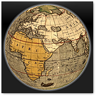
Historical Map 1544 Historical world map from the year 1544. Author: Battista Agnese in 1544. Credits: Library of Congress, American Memory. License: Public domain |
Download version 1.0 |

|
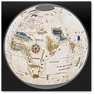
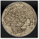
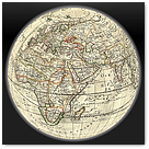
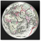
Historical Map 1570 Historical world map from the year 1570. Published as part of the first modern atlas ("Theatrum Orbis Terrarum"). Author: Abraham Ortelius in 1570. Credits: Library of Congress, Geography and Map Division. License: Public domain |
Download version 0.1 |
|
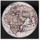
Historical Map 1589 Historical world map from the year 1589. Created and published by Gerard and Cornelis de Jode. Author: Cornelis de Jode in 1589. Credits: Sanderus Antique Maps. License: Public domain |
Download version 0.2 |
|
Historical Map 1595 Historical world map from the year 1595. Records the first English circumnavigation of the globe. Author: Jodocus Hondius in 1595. Credits: Library of Congress. License: Public domain |
Download version 0.1 |
|
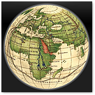
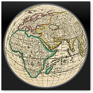
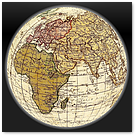
Historical Map 1630 Historical world map from the year 1630. Author: Henrik Hondius in 1630 in Amsterdam. Credits: State Library of New South Wales. License: Public domain |
Download version 0.1 |
|
Historical Map 1670 Historical world map from the year 1670. Author: Frederik de Wit 1670. License: Public domain |
Download version 0.1 |
|
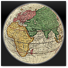
Historical Map 1691 Historical world map from the year 1691 in french language. Converted for use in Marble by Krutki Tamás. Author: Nicholas Sanson and Alexis Hubert Jaillot in France. Credits: Geographicus Rare Antique Maps. License: Public domain |
Download version 0.2 |

|
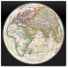
Historical Map 1720 Historical world map from the year 1720. The map shows nautical exploration routes. Author: Guillaume de L'Isle in 1720 in Paris. Credits: Library of Congress, Geography and Map Division. License: Public domain |
Download version 0.1 |
|
Historical Map 1744 Historical world map from the year 1744 with ocean winds. Converted for use in Marble by Gábor Péterffy. Author: Emmanuel Bowen in 1744. Credits: Geographicus Rare Antique Maps. License: Public domain |
Download version 0.1 |
|
Historical Map 1786 Historical world map from the year 1786. Author: William Faden in 1786, London. Credits: Library of Congress, Geography and Map Division. License: Public domain |
Download version 0.1 |
|
Historical Map 1794 Historical world map from the year 1794. Author: Samuel Dunn and Thomas Kitchin in 1794, London. Credits: Geographicus Rare Antique Maps. License: Public domain |
Download version 0.1 |
|
Historical Map 1866 Historical world map from the year 1866. The map displays routes of important explorers. Author: Samuel Augustus Michell in 1866. Source: Geographicus Rare Antique Maps. License: Public domain |
Download version 0.1 |
|
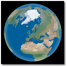
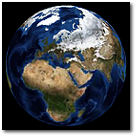
Natural Earth III Natural Earth III portrays the world environment in an idealized manner with little human influence. Author: Tom Patterson, www.shadedrelief.com, 2008. License: Public domain |
Download version 0.1 |
|
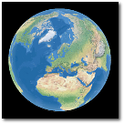
Natural Earth II - Oceans with layered depth. Natural Earth II portrays the world environment in an idealized manner with little human influence. This version displays oceans with layered depth. Author: Tom Patterson, www.shadedrelief.com, 2008. License: Public domain |
Download version 0.1 |
|
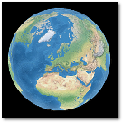
Natural Earth II - Oceans with blended depth tints and shading. Natural Earth II portrays the world environment in an idealized manner with little human influence. This version displays oceans with blended depth tints and shading. Author: Tom Patterson, www.shadedrelief.com, 2008. License: Public domain |
Download version 0.1 |
|
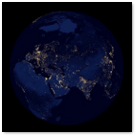
Earth at Night 2012 The night side of our planet twinkles with light, and the first thing to stand out is the cities. Author: NASA Earth Observatory. License: Public domain |
Download version 1.0 |

|
OpenSeaMap A global seamap. Converted for use in Marble by Anders Lund Author: OpenStreetMap (OSM) and the OpenSeaMap project. License: Creative Commons by-SA 2.0 |
Download version 0.1 |

|
Cycle Map A global cyclemap created by the OpenStreetMap (OSM) project. Author: The OpenCycleMap was created by Andy Allan and Dave Stubbs. License: Creative Commons by-SA 2.0 |
Download version 0.5 |

|
Hike and Bike Map A global hike and bike map created by the OpenStreetMap (OSM) project. Author: Colin Marquardt. License: Creative Commons by-SA 2.0 |
Download version 0.3 |
|
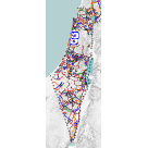
Israel Hiking Map A hiking map created using data by the OpenStreetMap (OSM) project. Author: OpenStreetMap (OSM) and Boris Shtrasman License: Creative Commons by-SA 2.0 |
Download version 0.2 |
|
|
Public Transport A global map created by the OpenStreetMap (OSM) project. Author: Melchior Moos based on data gathered by the OpenStreetMap community. Converted for use in Marble by Paul Kocialkowski. License: Creative Commons by-SA 2.0 |
Download version 0.1 |
|
MapQuest OSM A global road map created by MapQuest based on data of the OpenStreetMap (OSM) project. Author: MapQuest License: MapQuest Services License and Open Data Commons Open Database License (ODbL) |
Download version 1.0 |
|
MapQuest Open Aerial A global satellite map created by MapQuest Author: MapQuest License: MapQuest Services License and MapQuest Content License |
Download version 1.0 |
|
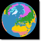
Climate Zones Climate zones of the world. Converted for use in Marble by Mohammed Nafees. Author: LordToran based on Peel, M. C. and Finlayson, B. L. and McMahon, T. A. License: Creative Commons by-SA 3.0 |
Download version 0.1 |
|
Moon - 1609 - Thomas Harriot First telescopic drawing of the moon surface showing craters. Converted for use in Marble by Abhishek Arora. Author: Thomas Harriot in 1609. License: Public domain |
Download version 0.1 |
|
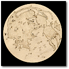
Moon - 1645 - Hevelius An early map of the moon created shortly after the telescope was discovered. Author: Johannes Hevelius in 1645, published in "Selenographia, sive Lunae descriptio". License: Public domain |
Download version 0.2 |
|
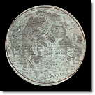
Moon - 1707 - Homann and Doppelmayr A map that compares the different lunar nomenclatures of Hevelius and Riccioli. Converted for use in Marble by Mohammed Nafees. Author: Homann and Doppelmayr in 1707. License: Public domain |
Download version 0.1 |
|
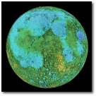
Moon - Elevation Color-coded elevation data of the Moon. Author: NASA/SDIO, Courtesy USGS Astrogeology Research Program. License: Public domain |
Download version 0.2 |
|
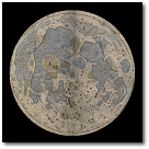
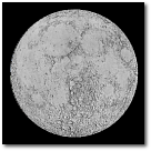
Moon - Shaded Relief Shaded Relief or "Hillshade" Topographic Map of the moon. Author: NASA, 2002. Courtesy USGS Astrogeology Research Program. License: Public domain |
Download version 0.2 |
|
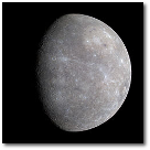
Mercury Mercury based on the Mariner 10 and messenger missions. Converted for use in Marble by Timothy Lanzi. Author: NASA/SDIO, Courtesy USGS Astrogeology Research Program. License: Public domain |
Download version 0.1 |

|
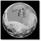
Venus Venus shown without its permanent cloudcover based on Magellan radar data. Author: NASA/JPL-Caltech. License: Public domain |
Download version 0.3 |
|
Venus Topography The color-coded topography of Venus based on Magellan radar data. Converted for use in Marble by Gábor Péterffy. Author: NASA/JPL-Caltech. License: Public domain |
Download version 0.2 |
|
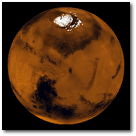
Mars Mars in natural colors based on Viking material. Author: NASA, Courtesy USGS Astrogeology Research Program. License: Public domain |
Download version 0.4 |
|
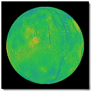
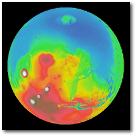
Mars Topography The Mars Global Surveyor mission carried the Mars Orbiter Laser Altimeter (MOLA) instrument, which measured the height of surfaces on Mars. Author: NASA, Courtesy USGS Astrogeology Research Program. License: Public domain |
Download version 0.1 |
|
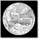
Mars - 1886 - Schiaparelli. A historical Mars map that shows the "mars canals" as seen by Giovanni Schiaparelli in 1886. Converted for use in Marble by Gábor Péterffy. Author: Giovanni Schiaparelli License: Public domain |
Download version 0.1 |
|
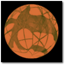
Mars - 1895 - Lowell. A historical Mars map that shows the "mars canals" as seen by Percival Lowell in 1895. Converted for use in Marble by Gábor Péterffy. Author: Percival Lowell License: Public domain |
Download version 0.1 |
|
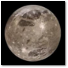
Jupiter - Ganymede A map of Jupiter's icy moon Ganymede. Converted for use in Marble by Armen Rissmiller. Author: NASA, Courtesy USGS Astrogeology Research Program License: Public domain |
Download version 0.1 |
|
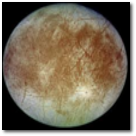
Jupiter - Europa A map of Jupiter's icy moon europa, which may have life locked in oceans under it's ice. Converted for use in Marble by Armen Rissmiller. Author: NASA, Courtesy USGS Astrogeology Research Program License: Public domain |
Download version 0.1 |
|
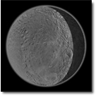
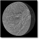
Saturn - Rhea Saturn's moon map of Rhea based on the missions of the Cassini and Voyager spacecraft. Converted for use in Marble by Gabriel Esteban. Author: NASA, Courtesy USGS Astrogeology Research Program License: Public domain |
Download version 0.1 |
|
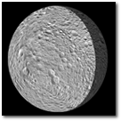
Saturn - Mimas A map of Saturn's moon Mimas. Converted for use in Marble by Gabriel Esteban. Author: NASA, Courtesy USGS Astrogeology Research Program License: Public domain |
Download version 0.1 |
|
Saturn - Dione A map of Saturn's moon Dione based on the Cassini and Voyager missions. Converted for use in Marble by Gabriel Esteban. Author: NASA, Courtesy USGS Astrogeology Research Program License: Public domain |
Download version 0.1 |
|
Saturn - Titan A map of Titan made by NASA's Cassini orbiter in April 2011. Author: NASA/JPL-Caltech/Space Science Institute License: Public domain |
Download version 0.1 |